
Click on the links below for pictures of our month in the Hebrides. Then click on the tab at the bottom of the new page and when the Picasa screen opens click on Slideshow so that the photos run through. You can also click on the map on the RH side to see where the photos were taken. If you use the Full Screen option you will need to move the cursor to the top of the screen to be able to exit this tab.
Hebrides Background explains how to get there and travel
around and illustrates some of the major points of interest to be encountered on any visit.
Vatersay, Barra and South Uist shows pictures from the 3 most
southerly inhabited islands
Benbecula, North Uist and Berneray covers the mainly flat
peneplained landscape of the central islands
Harris features the most rugged terrain of the island chain with
the highest point of the Outer Hebrides. It is also home to the famous tweeds.
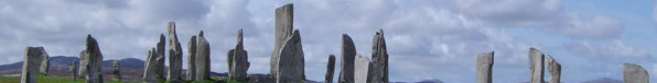
Lewis is the most northerly and the most populous district of the islands. It shares the large north island with the district of Harris and is home to the majority of the main historic sites.